35 minutes ago
3
35 minutes ago
3

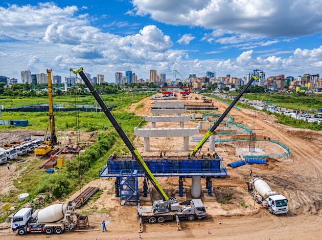 Construction work on the new Jangwani bridge across the flood-prone Msimbazi valley in Dar es Salaam. The elevated road is designed to keep traffic moving when heavy rains inundate the area. Credit: Kizito Makoye/IPS
DAR ES SALAAM, Tanzania, October 9 (IPS) - Each morning on her way to Kariakoo, Clementina Nyangwine looks out of her commuter bus as it crawls through Jangwani and watches giant foundation piles rising above the muddy Msimbazi valley.
Workers in safety helmets and high-visibility vests move among towering reinforcement cages. Cranes swing over the site while excavators, concrete mixers and trucks rumble below. Deep foundations are being driven into the quagmire for a bridge that will carry one of Dar es Salaam’s busiest roads above the floodplain.
Nyangwine, a 37-year-old shopkeeper, remembers what travelling through Jangwani was like when the Msimbazi River burst its banks.
“I have spent hours here waiting for the water to go down,” she told IPS. “Sometimes we got out of the bus and walked because there was no other way to reach Kariakoo. You would arrive at work with your clothes soaked in muddy water.”
On the worst days, passengers waited on the edge of Morogoro Road as murky floodwater swept across the carriageway.
“You could not tell whether you would reach work in an hour or four hours,” Nyangwine said. “When I see this bridge coming up, I think perhaps those days are finally ending.”
The bridge is part of the Msimbazi Basin Development Project, an effort to reduce chronic flooding in Dar es Salaam as climate risks intensify.
At the centre of the work is a 390-metre bridge about eight metres above the existing road level, allowing traffic to continue moving even when the Msimbazi swells during heavy rains.
The wider construction corridor stretches for about 1.2 kilometres and includes approach roads. The bridge will be approximately 41 metres wide and will accommodate vehicles as well as pedestrians, cyclists and the Bus Rapid Transit system.
In August, the Tanzania National Roads Agency, TANROADS, said construction had reached 41 percent.
Building Above the Flood
Project manager Leonard Ngayungi said the height of the new bridge is central to its design.
“The problem with the existing crossing is that the road sits within an active floodplain,” Ngayungi told IPS. “When the Msimbazi rises, water spreads across Jangwani, and the road becomes part of the flood area. We are changing that relationship by taking the transport infrastructure above the flood level.”
The bridge is being supported by hundreds of deep foundation piles driven between 35 and 42 metres underground, depending on soil conditions. Of the roughly 496 piles required, 404 had been completed, according to officials.
Ngayungi said the aim is not simply to build a stronger road but to let the river and floodplain carry water without cutting one of the city’s main transport links.
“The bridge is being designed so that the river can flow perpetually underneath while people, buses and other vehicles continue to move above.” Ngayungi said.
“We have to build for the rainfall we may face in the future, not simply the rainfall patterns people remember from 20 or 30 years ago,” he said.
A River That Can Stop a City
The Msimbazi is a relatively small river with an outsized impact on Dar es Salaam.
Its basin is home to approximately 1.6 million people and cuts through densely populated neighbourhoods.
Near Jangwani, two of Dar es Salaam’s major traffic arteries cross the lower floodplain, including the corridor used by the city’s first Bus Rapid Transit system.
When the river floods, therefore, the consequences spread far beyond households living beside its banks.
Roads close. Buses stop. Workers arrive late. Traders lose customers. Goods cannot move easily between the city centre and its western suburbs.
Issa Majega, 56, a BRT driver on the Kariakoo-Kimara route, said heavy rain can turn a routine journey into hours of uncertainty.
“Once Jangwani floods, everybody suffers,” Majega told IPS. “The buses cannot pass, passengers become stranded and traffic builds up on other roads because everyone is looking for another route.”
For drivers, he said, the danger is knowing when to stop.
“You cannot gamble with a bus full of people when water is crossing the road,” he said. “Even if passengers are in a hurry, you have to wait.”
Majega believes the elevated crossing could remove a persistent bottleneck in the city’s transport system.
“If this bridge works as designed, rain will no longer mean that the whole route has to stop because of Jangwani,” he said.
Climate Change Meets Urban Growth
Dar es Salaam’s flooding problem cannot be blamed on rainfall alone.
Rapid urban sprawl has pushed settlements into wetlands and floodplains, while buildings and roads have reduced the land available to absorb rainwater. Rubbish chokes drainage channels, while sediment has accumulated in parts of the Msimbazi.
About 70 percent of Dar es Salaam’s residents live in informal settlements, many with inadequate drainage. In 2018, a major flood in the Msimbazi basin caused an estimated US$100 million in damage — equivalent to roughly two percent of the city’s gross domestic product, according to World Bank figures.
Deusdedit Rwehumbiza, an urban planning professor at Mkwawa University in Iringa, says that is why the project should not be understood simply as a bridge-building exercise.
“The bridge is the most visible part because everybody can see the cranes and concrete,” Rwehumbiza said. “But the real issue is how you manage an entire urban watershed.”
“The strength of the Msimbazi approach is that it treats flooding as a land-use, environmental and transport problem at the same time,” Rwehumbiza said.
The project also includes river improvements, floodplain restoration, watershed management and better solid-waste management. Parts of the lower basin are intended to become flood detention areas that temporarily hold excess water.
“That is what climate adaptation should do,” Rwehumbiza said. “You give water somewhere safe to go instead of spending every rainy season trying to fight it after it has already entered people’s homes.”
Moving People Out of Harm’s Way
Around 3,500 households living in the Msimbazi floodplain were targeted for resettlement, with US$30 million allocated for compensation. Among them was Teresia Katimba, a mother of four who moved to Madale in 2024 after years of enduring floods that repeatedly filled her Jangwani home with sewage and rubbish.
“A climate-resilient city cannot simply move risk from the river to people’s livelihoods,” Rwehumbiza said. “If families are safer from floods but cannot afford transport to work, you have solved one problem and created another.”
US$260 Million Bet on Resilience
The World Bank’s International Development Association is providing US$200 million in concessional financing, while Spain and the Netherlands are contributing additional financing that brings the package described by Tanzanian authorities to around US$260 million.
The project, scheduled to run through 2028, covers the lower Msimbazi basin and extends work farther upstream towards the Pugu Hills.
TANROADS is responsible for the Jangwani bridge works, while other government institutions are involved in the redevelopment of the wider valley.
Authorities also envisage markets, commercial development and improved public transport in the redeveloped valley.
But Rwehumbiza said the project’s success will also depend on controlling waste, sediment and development upstream.
“You can build a bridge to last many decades,” he said, “but the river is connected to everything happening upstream. Climate resilience requires maintaining the whole system.”
For commuters, the test will come on a rainy morning when the Msimbazi rises.
For years, Jangwani has represented a peculiar vulnerability in Dar es Salaam: a short stretch of road where a downpour could interrupt journeys across a metropolis of millions.
As climate change increases the risks facing fast-growing African cities, such weak points are becoming increasingly expensive.
It will not prevent heavy rain. Nor can one bridge make Dar es Salaam climate-proof.
Nyangwine still remembers stepping out of stalled buses, lifting her skirt and walking gingerly along Morogoro Road as filthy water splashed around her legs.
Occasionally she reached her Kariakoo shop hours late. Sometimes customers had already left. On the journey home, another downpour could begin the ordeal again.
Now, each time her bus passes Jangwani, she watches the workers.
“The river will still flood when the rain is heavy,” she said. “But if people can cross safely above it, then the rain does not have to stop our lives.”
IPS UN Bureau Report



© Inter Press Service (20261009145355) — All Rights Reserved. Original source: Inter Press Service